Potential to Positive!
Geography

India is the seventh largest country in the world. In this very large country are multiple distinct geographical features. There are seven prominent regions: The Northern Mountains, The Indo-Gangetic Plains, The Thar Desert, The Central Highlands and Deccan Plateau, The East Coast, The West Coast, and Bordering Seas and Islands.
The Northern Mountains
Sectioning India off from the rest of South Asia are a series of mountain ranges. While the widely-known Himalayas border most of India, other mountain ranges include the Hindu Kush, Karakoram, and Patkai ranges. These mountain ranges cover at least five of India's 28 states.


The Hindu Kush Mountains The Himalayas
The Indo-Gangetic Plains
Named after the Indus and Ganges Rivers (India's two main rivers), the Indo-Gangetic Plains dominate North India. Flat, and with fertile soil, most Indian farmers live here. The Indus River Delta and Ganges River Delta both run through this region.


Indus River Ganges River
The Thar Desert
Located in Northeastern India, the Thar Desert is a vast plain of rolling hills and sand dunes. Because of its little rainfall and dry climate, the Thar Desert, while beautiful, is thinly populated and an inconvenient area for natural resources.

The Central Highlands (Deccan Plateau)
A semi-arid region, the Central Highlands consist of three plateaus, the main one being the Deccan Plateau. The Highlands gently slope from east to west and hold other Indian regions, such as the Krishna and the Kavari. The slope helps these rivers flow into the Bay of Bengal.

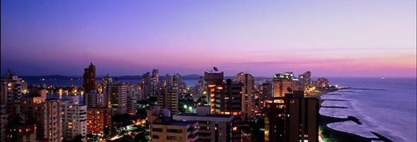
The East and West Coasts
The coastal plains of India are very similar. Both are long stretches of land along either side of India. The Eastern Coast receives much more rainfall, though. Both coasts have beautiful beaches with large cities.
Offshore Islands
Small islands are sprinkled off each coast of India, and while they don't take up the majority of India's geographical area or population, they contain gorgeous beaches and are a great place for tourists.

Andaman Islands
Political

India, a country with an area of 1,269,219 square miles, is divided into 28 states and 7 union territories. India is bordered by Nepal, Bangledash, Pakistan, and China. Its water borders are the Bay of Bengal, the Indian Ocean, and the Arabian Seas.